Sunday, March 11, 2012

March 8 - Coinjock, NC to Portsmouth, VA

Our last day of cruising took us from Coinjock to the Virginia Cut and on to the Great Bridge Lock. We were locked through with a tug that had been cruising with us for a few hours. In the early after- 
noon we arrived in the greater Portsmouth and Norfolk area.  Here we saw a bridge being constructed across the Elizabeth River.  After a delay of just over one hour, we cleared the Gilmerton Bridge. After  
this delay, things went much better. We passed naval yards with decommisioned ships, including an aircraft carrier. Next stop was at the Ocean Marine Yacht Center where our boat will be stored until mid June. Across from the marina one could see a number of Navy vessels in for repairs/updating. In a few days our boat will be pulled out of the water and placed on "the hard." It's been a great trip thus far and we look forward to resuming our Great Loop trip around the third week of June. At that time we will resume publishing our blog. Until then!

Saturday, March 10, 2012

March 7 - Alligator River Marina to Coinjock, NC

Since the Dismal Swamp route was closed for some days, we continued via the Albemarle Sound to the North River and on to Coinjock. To the left is the Shell gas station and marina where we had spent the night. As we proceeded up the North River, we passed another dredge being pulled to a new location along the ICW. Arrival in the small town of Coinjock was around lunch time. Since our trip was coming to an end, Thressa   
took care of packing up and Henk gave the boat another cleaning - salt water does require more washing then fresh water. We also took on 285 gallons of diesel and enjoyed a great fish dinner at the marina restaurant. Tomorrow is to be the last day of our "Winter trip".

March 6 - Belhaven to Alligator River Marina

The wind was way down, what a difference from yesterday afternoon and evening. We followed the Pungo River to the start of the Alligator River-Pungo River Canal, a 21 mile stretch through marshes and forests. During 2003, Hurricane Isabel brought water levels up to the 60 ft vertical clearance line on the bridge (see above) tide board. Shortly after having entered the canal, a boat passed at high speed. All of a sudden it stopped and shortly thereafter they called us for assistance. It seems they had hit a log and
were taking on water. So that the boat would not sink, they ran it aground. At their request, we stayed close until the Coast Guard arrived. After the canal section, the Alligator River became much wider and ended up flowing into the Albemarle Sound. After going through the Alligator River Swing Bridge, we docked at the nearby Aligator River Marina. The marina was in the process of opening up for the season.

Thursday, March 8, 2012

March 5 - River Dunes to Belhaven, NC

More "stress for Thress" was on today's agenda. The Pamlico Sound was still rough, but soon the route took us inland with good protection from the strong wind. This protection was lost when we had to cross the Pamlico River. The Pungo River was even rougher - things that were not tied down or behind locked doors went flying.  Our marina for the
night was Dowry Creek Marina, located just east of Belhaven. We were met by friendly staff and fellow boaters who all
helped getting us tied up. Afterwards we learned that we had battled wind gusts that had been clocked as high as 55 miles per hour. Around the marina we could see reminders of huricanes that had hit this area. Luckily the winds were forecast to diminsh and tomorrow was to be a great day.

March 4 - Beaufort to River Dunes, NC

It rained until 11:00 a.m. with more rain forecast for the afternoon. We decided to leave and cruise to River Dunes, a planned community with World Class Amenities.  After a few hours, the rain stopped, the wind picked up and the sun started to peak through the clouds.  Around mid afternoon we came to the Neuse River that runs into the Pamlico Sound. This area, along with Albemarle Sound is one of the meanest and roughest on the ICW. Since it is quite shallow, we had to go out quite a ways into the Pamlico Sound with strong wind and waves on the beam. The ride was certainly "lots of stress for Thress". We finally reached the Broad Creek where we were in protected waters.
As we motored into the River Dunes harbour, the view was hard to believe. In the middle of "no where" was a beautiful marina community.  You have to see it too believe it. Since it was "off season", we were one of the only boats with people staying onboard. The majority of the homes, condos and cottages were also not occupied.  We  had a very peaceful night of rest.

March 3 - Swan Point to Beaufort, NC

We tried once again to find someone so that we could pay our dockage fee. The only living thing around was this bird. Thus we had a freeby! Our route took us along  the New River, with occasional views of the Atlantic, to Swansboro and on to Beaufort. At two spots the Corps of Engineers was hard at work with dredging the ICW. The weather was not great - lots of wind and rain. After boating through Morehead City, we came to Beaufort, a town that was incorporated in 1722. We docked at the very centrally located Beaufort Docks. Six years ago we greatly enjoyed exploring this historic city, this however was not the case this year. The weather was horrible and the forecast for tomorrow even worse. We ate onboard and played a couple games of gin. Thressa won both games. It continued to rain all night.

Tuesday, March 6, 2012

March 2 - Southport to Swan Point, NC

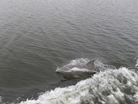
It was quite foggy this morning, but luckily it soon cleared enough so that our visibility was at least one to two miles. We crossed the Cape Fear River and cruised by way of Snows Cut Canal to Carolina Beach. A number of dolphins were swimming along and Thressa was lucky to photograph them just at the right moment. Carolina Beach  is a popular vacation area with a number of marinas.
During the next 50 miles we passed Wrightsville Beach and Surf City. The last 10 miles were a bit more difficult in view of thick fog. With the help of our course plotter and radar, we made it to our destination - Swan Point Marina and Boatyard, close to the New River Inlet. The marina was a mess, it seems that it had closed down. There was no one around and the building that was the office and marine store was completely empty. There were some boats in the marina with "live aboards". We found a good place to tie up and had a good night's rest.

Sunday, March 4, 2012

March 1 - Myrtle Beach to Southport, NC

After clearing this swing bridge, we continued our trip to the north - and into a colder region then what we have been used to. The distance to be covered was only 45 mi. Weather started with grey skies, then some sunshine and later back to partial cloudy skies with lots of wind. As we cruised along the ICW, we came past a number of inlets, allowing us
to see the Atlantic Ocean. There were also stretches with many large homes with boat docks and boat lifts. In view of the difference between high and low tide, docks and boat lifts are often a long way from shore with long wooden walkways connecting them. In the early afternoon we arrived at Deep Point Marina, just a few miles north of Southport. The marina was off the Cape Fear River, connecting Wilmington with the Atlantic. We saw a number of ocean going vessels pass our marina. After "pumping out", we continued to our slip. The harbour also served as a terminal for a couple ferries.